Бюлетені
Публікації
-
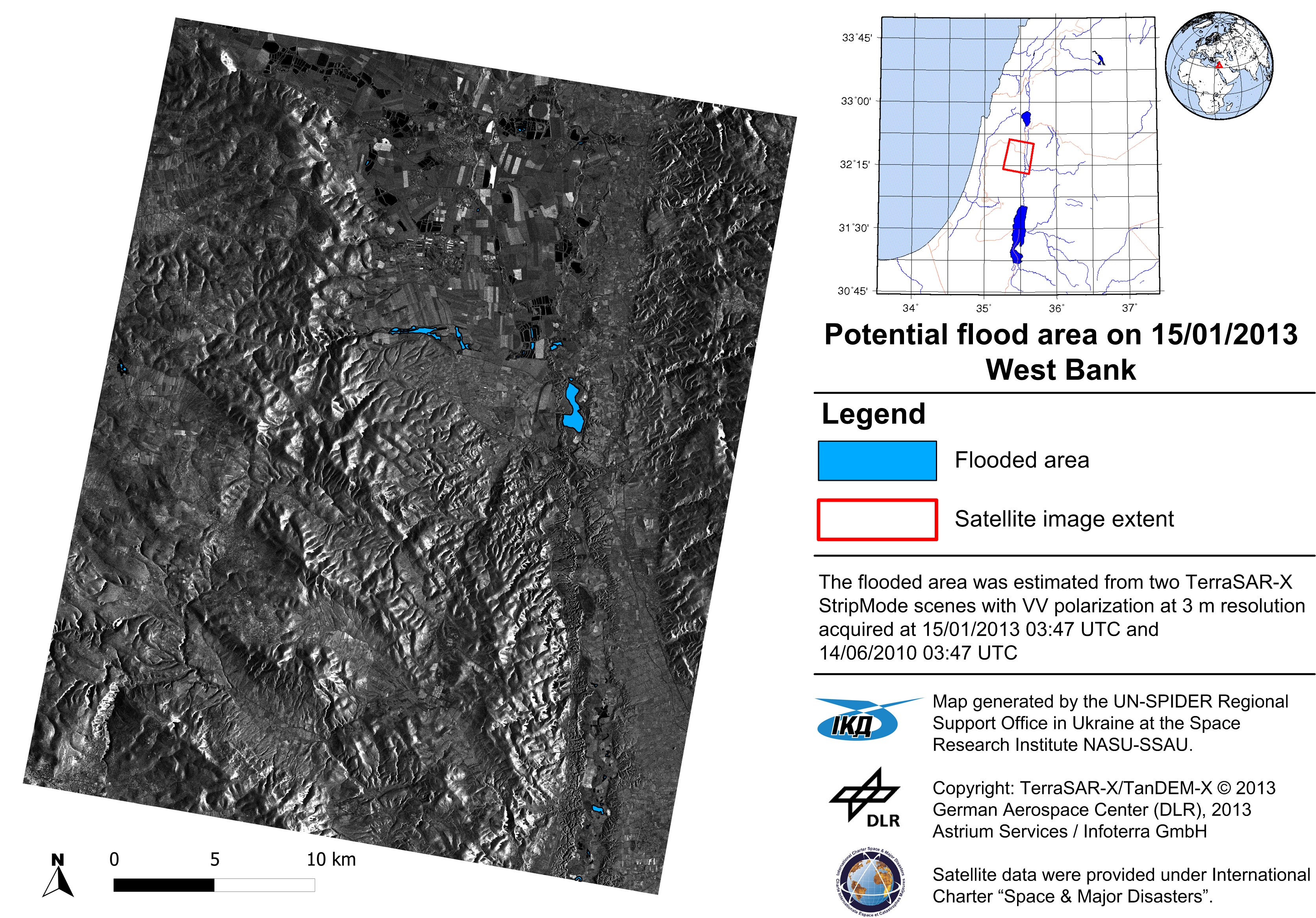
- S. Skakun, et al. Flood Hazard and Flood Risk Assessment Using a Time Series of Satellite Images: A Case Study in Namibia // Risk Analysis. — 2013. — doi: 10.1111/risa.12156.
- D. Mandl, et al. Use of the Eearth Observing One (EO-1) Satellite for the Namibia SensorWeb Flood Early Warning Pilot // IEEE Journal of Selected Topics in Applied Earth Observations and Remote Sensing. — 2013. — Vol. 6, no. 2. — P. 298–308.
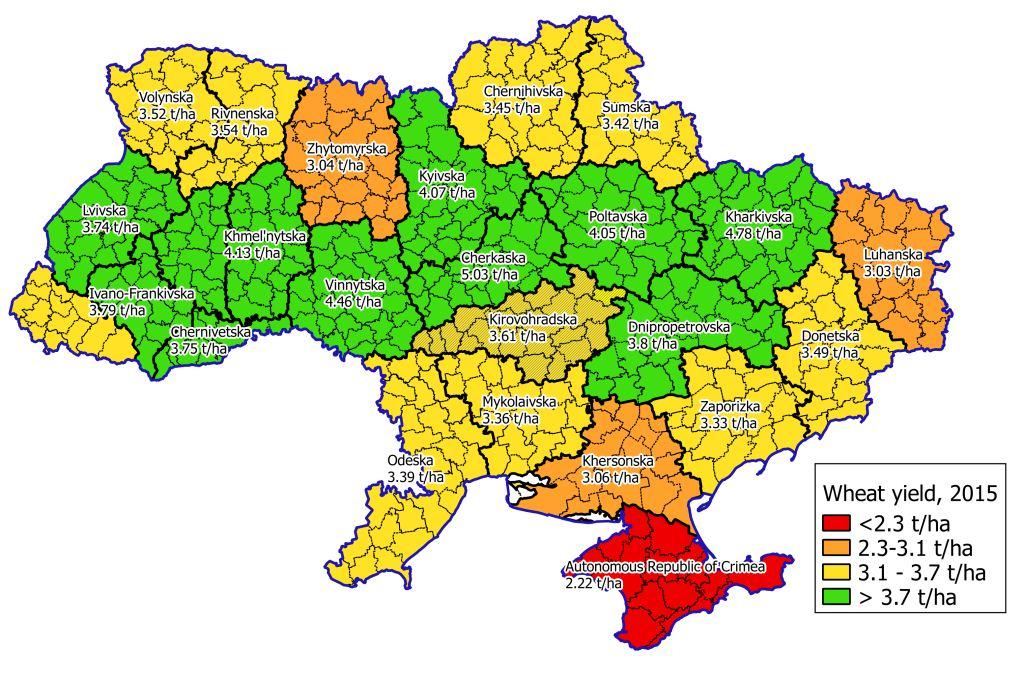
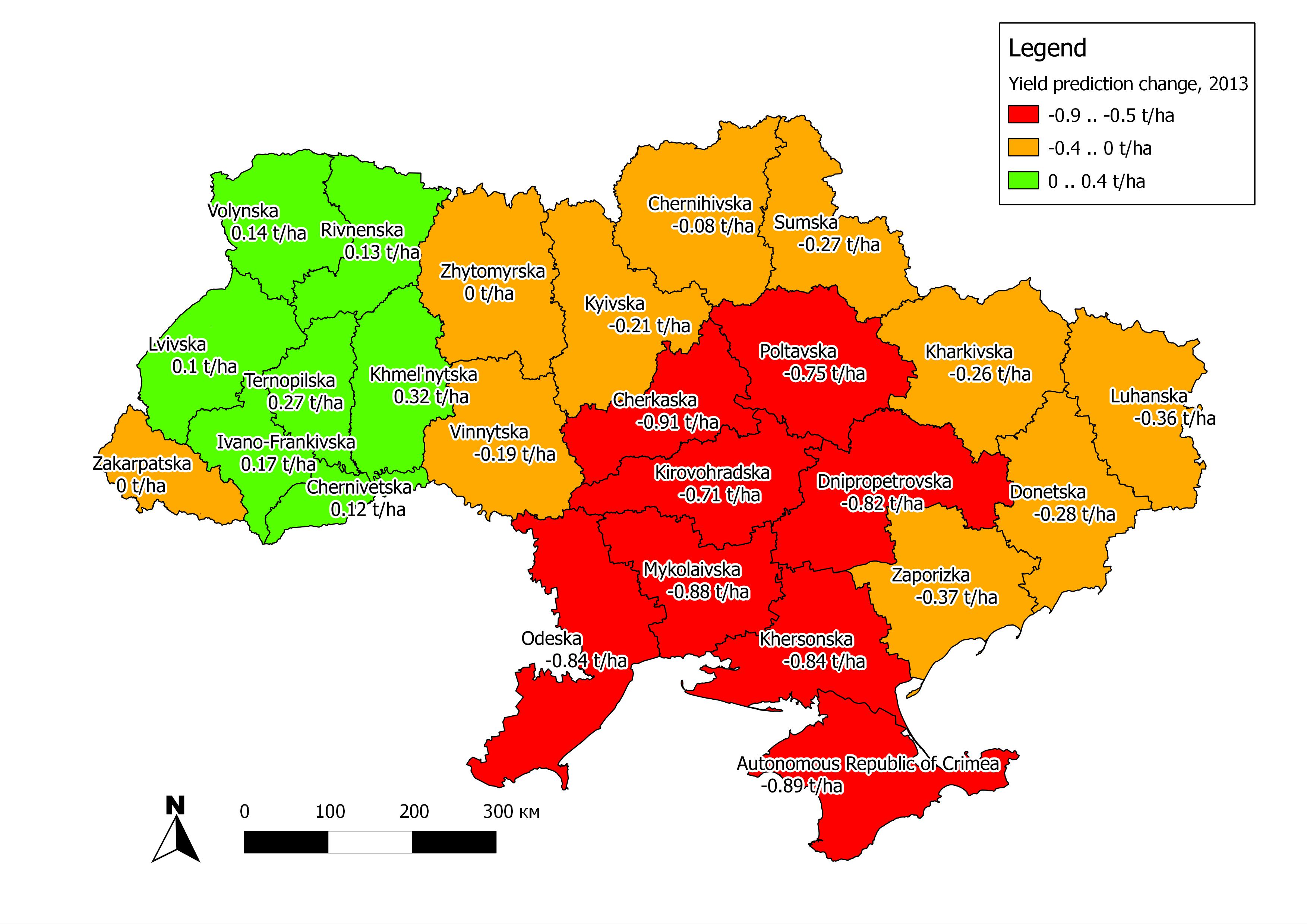
- Kogan, F., N. Kussul, et al. “Winter wheat yield forecasting in Ukraine based on Earth observation, meteorological data and biophysical models” International Journal of Applied Earth Observation and Geoinformation. — 2013. — vol. 23 — PP. 192-203.
- Kussul N., Mandl D., Moe K., Mund J.-P., Post J., Shelestov A., Skakun S., Szarzynski J., Van Langenhove G., Handy M. “Interoperable Infrastructure for Flood Monitoring: Sensor Web, Grid & Cloud”, 2012, vol. 5, no.6, pp. 1740-1745.
- Kussul N., Shelestov A., Skakun S. / “Technologies for Satellite Data Processing and Management Within International Disaster Monitoring”, In Fiore, S.; Aloisio, G. (Eds.) “ Grid and Cloud Database Managment Grid”. - Springer. Projects, 2011, Р. 279-306.
- Kussul N., Shelestov A., Skakun S. “Flood Monitoring on the Basis of SAR Data”, In F. Kogan, A. Powell, O. Fedorov (Eds.) “Use of Satellite and In-Situ Data to Improve Sustainability”. – NATO Science for Peace and Security Series C: Environmental Security,Springer, 2011, P.19-29
- Kussul N., Shelestoov A., Skakun S., Kravchenko O. “High performance Intelligent Computations for Environmental and Disaster Monitoring”, In Intelligent Data Processing in Global Monitoring for Environment and Security (Krassimir Markov, Vitalii Velychko editors). — I T H E A, Sofia, 2011, рр. 76-103.
- Skakun S. “A Neural Network Approach to Flood Mapping Using Satellite Imagery”, Computing and Informatics. – 2010. – Vol. 29, No. 3 – P. 1001-1012.
- Kussul N., Shelestov A., Skakun S. Geo-information infrastructure to environmental and disasters monitoring // Science and Innovation. – 2010. Vol. 6, No. 4. – P. 13-20. (in Ukrainian)
- Skakun S. Geo-information service for flood monitoring using satellite data // Science and Innovation. – 2010. – Vol. 6, No. 4. – P. 21-28. (in Ukrainian)
- Shelestov A., Kussul N., Skakun S., Mironov A. Service-oriented infrastructure for floods monitoring using satellite data // DonNTU Series “Informatics, cybernetics and computer engineering”. – 2010. Issue 11(164). – P. 133-139. (in Ukrainian)
- Skakun S. Flood risk assessment using heterogeneous geospatial data // DonNTU Series “Informatics, cybernetics and computer engineering”. – 2010. Issue 12(165). – P. 94-98. (in Ukrainian)
- Kussul N., Shelestov A., Skakun S. “Grid and sensor web technologies for environmental monitoring”, Earth Science Informatics – 2009. — Volume 2, Numbers 1-2. – P. 37-51.